Glastenbury Mountain Cairn Site
by Norman E Muller
Just northeast of Bennington, Vermont, at the southern terminus of the Green
Mountains and the Long Trail, is Glastenbury Mountain. It is not
particularly high in comparison to other New England mountains, being
only 3750 feet in elevation and wooded to the summit, but it is
nevertheless a massive mountain and difficult to access. The usual
route to the summit, as mentioned in the guidebooks, is the Long Trail,
which exits from the trailhead on Route 7 just outside Bennington. For
those intending an extended trip along the Long Trail, it is a little
more than nine miles to the summit. A more direct route is by taking an
unmarked trail on the east side of Bolles Brook and just west of the
Long Trail. Still, it is a long six miles, much of it uphill.
About ten years ago, David Lacy, who is an
archaeologist with the Green Mountain National Forest in Vermont, was
checking the status of the fire tower on Glastenbury's summit,
and discovered several cairns just off the Long Trail, a couple of
hundred yards south of the fire tower on a nearly flat wooded plateau.
The entire mountain and surrounding area was being proposed for
wilderness status. Lacy wrote a report in support of this plan, in
which he said, 'At the summit of Glastenbury Mt. and within the
AT/LT [Appalachian Trail/Long Trail] corridor, are a cluster of three
sites: the National Register-eligible Glastenbury Mountain Fire Lookout
Tower, the remains of the associated caretaker's cabin, and at
least three stone cairns whose cultural origins are uncertain, but
which could well be prehistoric. 1
I found the report Dave Lacy wrote online, and
being interested in what he said about the cairns, I inquired about
them in
September 2006 2. I
had known Dave through our mutual interest in
a huge cairn site on West Hill in Rochester, Vermont. He sent me images
of the three cairns he had found and photographed on one of his trips
to the mountain (Figures 1-3).
The fact that the cairns were near a wooden platform of an abandoned
fire lookout cabin and within five hundred feet of the summit fire
tower made their origin slightly suspect, since the fire tower was
constructed in 1927 and the cabin around the same time. The Long Trail,
which provided access to the mountain top,
was cut around 1913-14. Before then there were no trails to the summit,
as indicated by an 1898 topographic map (Figure 4). Lacy and others
reasonably concluded that the cairns might have been constructed in the
period 1913-1930 by either the fire warden or those constructing the
Long Trail.
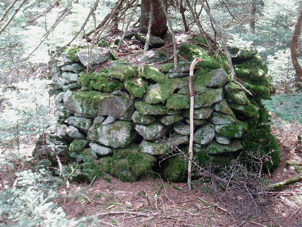
Figure 1. Cairn 'A' at Glastenbury Mountain site.
Courtesy David Lacy
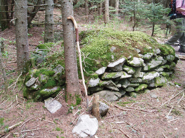
Figure 2. Cairn 'B' at Glastenbury Mountain site.
Courtesy David Lacy

Figure 3. Cairn 'C' at Glastenbury Mountain site.
Courtesy David Lacy
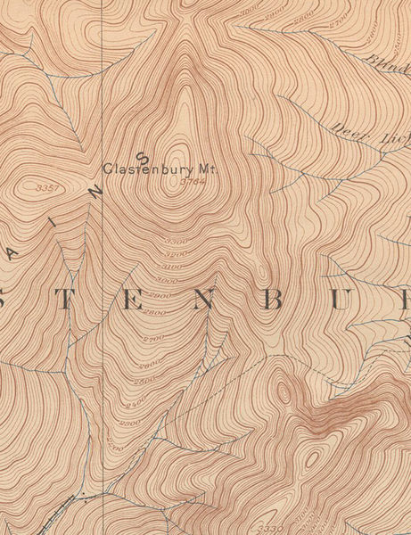
Figure 4. Topographic map from 1898.
Cairns are often found on the bare ridges
and summits of New England's highest mountains, where they help
to guide hikers in bad weather conditions. The ones on Glastenbury
Mountain were located off the Long Trail and were not built as trail
markers. Many of the cairn sites I have studied over the past eleven
years have been found on former farmland at much lower elevations.
Those on Glastenbury Mountain, having no association with any farming
activity, could be studied free from the complicated issues involving
cairns in a colonial farm setting. Thus the site could serve as an
excellent study case, and this seemed particularly attractive to me.
The cairns were carefully made, and the seemingly
largest one, being barrel-shaped, particularly interested me, since it
was structurally and stylistically similar to those I had seen at much
lower altitudes throughout New England. Those on Glastenbury were
certainly deserving of close study.
The thick moss cover on the cairns, visible in the images Dave sent me,
were intriguing, and I wondered whether this aspect might be
significant and an indication of their age. I sent an e-mail with one
of Dave's photographs to Tom Wessels, a forest ecologist and
author of the book Reading the
Forested Landscape, and asked him for his thoughts on the
heavily moss covered cairn (see
Figure 2), given its location and the climatic conditions
at that altitude. He wrote back January 4, 2007 with the following
comments:
'I think this one is very old! I have never seen any
colonial stone piles, generated in the late 1700s and early 1800s, that
have vegetated growth like
this on them. Moss coverage is one thing, but this structure has
succeeded to club moss and herbaceous coverage.
3
I replied with a fairly detailed description of the
site as described to me by Lacy, and a day later Tom wrote the
following:
'I'm very impressed!
At that elevation the successional process should be slow, particularly
due to restricted litter fall from the fir compared to the more robust
litter fall in a hardwood forest. You are correct these would have
nothing to do with agricultural activity at that elevation. Based on
the amount of herbaceous and club moss vegetative cover, I think there
is strong evidence that the third cairn that you attached is much older
than 200 years. I base this on numerous stone mounds I have examined
that were created on cultivated lands in the mid-1800s. That land was
subsequently abandoned in the late 1800s. So these mounds occur in a
115 year-old white pine/hemlock forest that would have litter fall
rates more similar to a fir forest than a hardwood forest, and are not
even close in the successional development to the cairns on
Glastenbury. This all suggests to me that the cairns on Glastenbury
pre-date European settlement of the region.
4
Not having seen the site and having questions about
the mineralogical nature of the stone and the physical nature of the
area around the cairns, I planned an initial trip to Glastenbury
Mountain in mid-June 2007. Tom Wessels was invited, but he had prior
commitments. Those in our party included: John Waltz, a friend and
colleague; Lisa Gannon; Dave Connelly, a friend and photographer at
Princeton University; and myself. Based on some information that Lacy
gave me, and perusing some topographic maps, I figured that the most
direct route up the mountain followed a trail on the east bank of
Bolles Brook. However, this trail was not marked with signs. Shortly
after it crossed Bolles Brook over a wooden bridge and began to climb,
John figured we should follow the ridge slightly to the east, where the
Maptech map indicated a straight-looking trail going directly up the
ridge to intersect with the Long Trail at Goddard Shelter. Or so we
thought. We took a short side trail'as shown on the topographic
map we had'to this other, main trail, and continued on it for a
while. But this trail petered out with thick brush and blowdowns, and
we were soon reduced to bushwhacking. Eventually we reached a private
cabin in a clearing, which was indicated on the topo map as a small
black square in a grey colored rectangle. At least we now knew where we
were, but after exploring the area north of the cabin for the supposed
trail to Goddard Shelter and finding nothing, we were in a quandary. We
had lost considerable time roaming around, and at that point we decided
we were going in the wrong direction. From the cabin we headed west
down a trail which intersected with the unmarked Bolles Brook trail,
about a quarter of a mile away. Once there, we headed north on the
Bolles Brook trail, but after a short while we heard thunder in the
distance, and the sky started to cloud up. Figuring we were about two
miles from the summit and a thousand feet below it, plus being tired
from all the effort we had already put into the climb, I suggested we
call it a day and return to our cars. It was a sad decision to make,
after all the planning and effort that had already gone into this trip.
But we turned around and walked the four or so miles back to our cars,
with the sound of thunder receding in back of us.
That August I decided to give the mountain another
try. Knowing a bit more about the mountain and the trails, I planned to
climb the mountain on September 8, and invited four others to join me.
In our group were: Ted Timreck, the documentary filmmaker; Tom Wessels;
Lisa Gannon; my son Peter; and myself. Ted recorded the trip on film.
After about four hours of climbing in muggy conditions along the
unmarked trail that followed Bolles Brook, and then along a side trail
to the Long Trail and the Goddard Shelter, we followed the Long Trail
toward the summit, eventually reaching the cairn location in a flat
area that had been used for camping. This spot was about 500 feet from
the summit and at the 3700 foot level. After the barrel cairn was
found, the others were easily spotted It turned out that the total
number of cairns was five and not three as Lacy had originally thought.
At this point I plotted the location of each cairn with a compass and
tape measure, and this information was used to create a map (Figure 5). Each cairn was then
identified with a letter, beginning with the barrel-shaped cairn,
labeled A, which was the most impressive visually.
Cairn A was
3' 7" high and 8' 3" in diameter, and was thought to be the largest of
the five. A large spruce tree had toppled years ago and was leaning
against the west side of the cairn. It had not caused any damage. Large
boulders, some of which must have weighed at least 200 pounds, formed
the base of the cairn. The rest were a mixture of large and smaller
boulders, some of which were in the hundred pound-plus range. The
largest boulder appears to be the long rectangular one visible in
Figure 1 1, just to the left of the walking stick. It is approximately
2' wide and 9" high, and must weigh about
300 lbs. Certainly two or more people were involved in constructing
this cairn. One can see how smaller stones were used to shim and level
larger boulders. This was a carefully planned and constructed cairn,
and is quite unique when compared to others in Vermont, most of which
are square, rectangular, or of irregular shape. The only circular cairn
I could think of that compares favorably with the one on Glastenbury is
located at site R7-6 in Rochester, Vermont. It is quite a bit wider
than the one on Glastenbury, but lower in height (Figure 6)
.
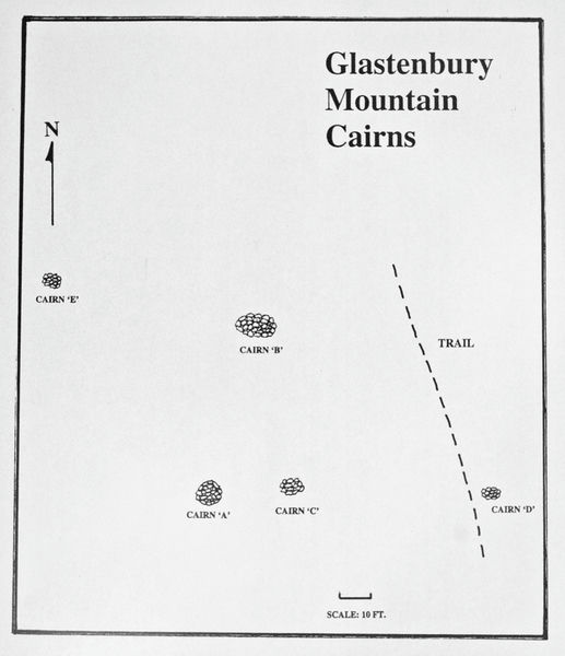
Figure 5. Plot showing the locations of each cairn.
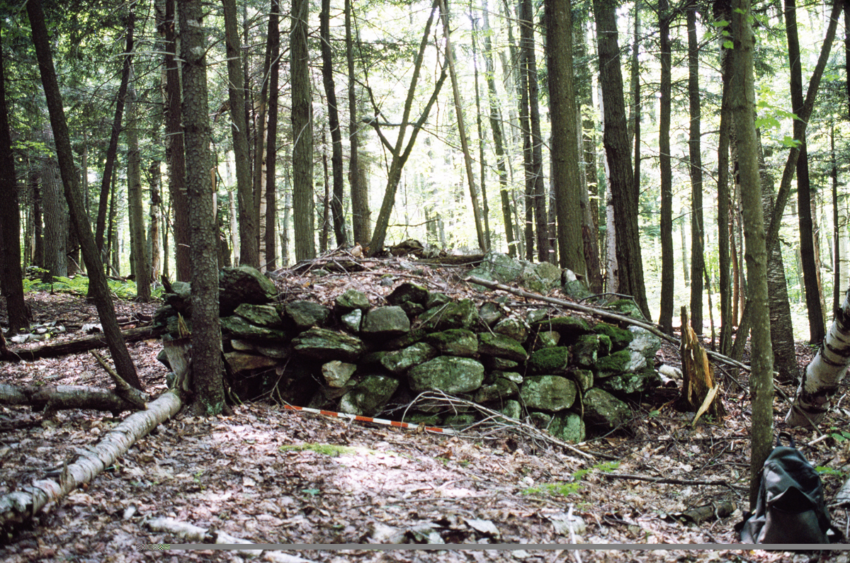
Figure 6. Cairn at site R7-6 in Rochester, VT.
Tom dug some soil away from one of the
base stones of Cairn A and discovered another stone underneath which
was buried at least six inches beneath the surface, due to a
combination of soil accumulation and bioturbation. A colleague in
Wisconsin said he had read that bioturbation accounts for approximately
one inch of soil each century. At this altitude the rates are probably
different. In any event, we were looking at a cairn of great antiquity.
Some in our group roamed around to determine if
there was an abundance of stones to construct cairns and to see if
there were other unidentified cairns, but nothing of significance was
found. One could see a stone here and a stone there, half buried in the
ground, but not in any great numbers. I kept looking for any anomalous
stones, such as quartz, but all the stones in the cairns seemed to be
local gneiss, called Mount Holly gneiss. I thought that perhaps
quartzite might be present, since Dave Lacy had told me that he had
found a quartzite procurement site on Bald Mountain, just west of
Glastenbury Mountain and connected to it by a ridge. Anomalous stones
had sometimes been found at other cairn locations, such as the half
dozen greenstones Harry Holstein of Jacksonville State University in
Alabama found on a cairn on the summit of Morgan Mountain in that
state's Calhoun County. Morgan Mountain rises some 321' above the
valley floor. Holstein and his team found six greenstone slabs having
an aggregate weight of 354 lbs. The nearest locality for greenstone
turned out to be a site some four miles away. As one of his colleagues
wrote, 'Regardless, the rocks would have had to be literally
carried or transported by man-induced means up Morgan Mountain and
subsequently placed in the burial sites. 5
Cairn B (Figure 2),
adjacent to the stone hearth was slightly larger in volume than Cairn
A, being 3' high by 12.5' long and 8' 3" wide. Considerable moss
covered the top, and two small birch trees were growing at the south
end. Wessels estimated the birch to be thirty years old.
Cairn C (Figure 3),
nearest Cairn A, was roughly round and 2' 4" high x 7' in one direction
and 7' 10" in another. It was nearly obscured by moss and herbaceous
cover.
Cairn D (Figure 7),
adjacent to the Long Trail was 1' 8" high by 5' 7" wide. It was perhaps
originally much larger, but its proximity to the trail might have
caused some of the stones to be removed, perhaps to build the
foundation of the former lookout cabin nearby.
Cairn E was located by others but neither seen, nor
photographed by me. It was forty to fifty feet west of cairn B.
Using Cairn A as the center, Cairns C and D aligned precisely east-west, and A and
B were north-south. Unfortunately, cairn E didn't seem to fit the
pattern.
While I was busy studying and photographing the barrel-shaped cairn,
Tom wandered over to the cabin platform and later pointed out to me
that the moss development on the foundation stones (Figure 8), which must have been
placed about the same time as the fire tower was built, was but a thin
patina compared to the thick mats of moss on some of the rocks
comprising cairns B and C, for instance (Figure 9 9). The platform was
only thirty feet or less from Cairn B and was certainly subject to the
same climatic conditions as the other cairns.
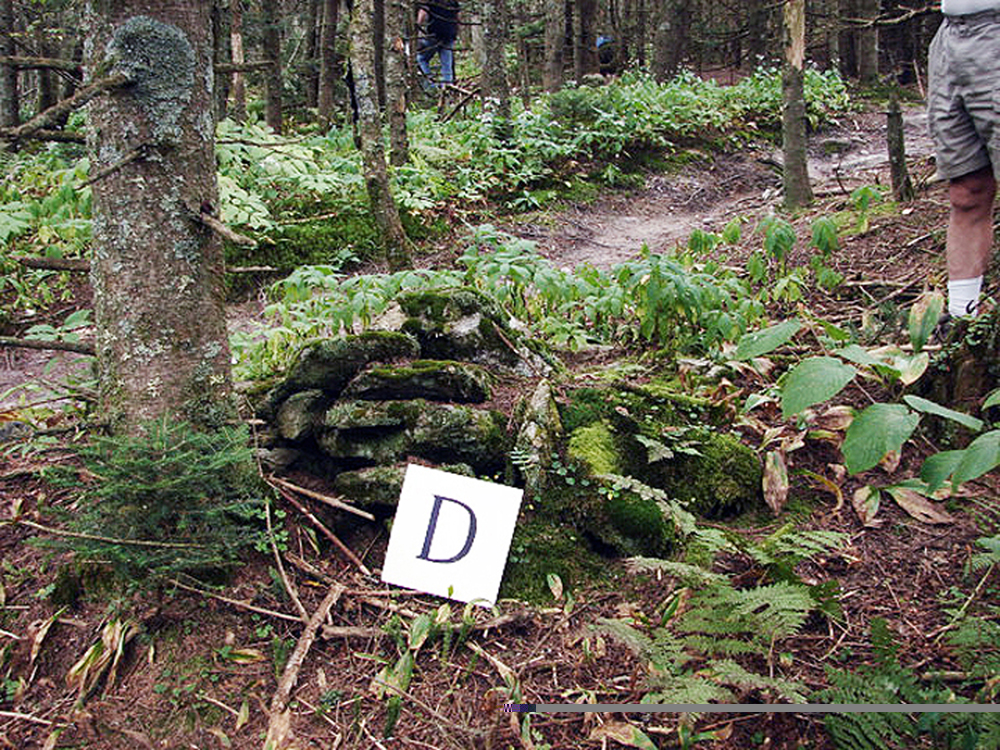
Figure 7. Cairn adjacent to Long Trail.
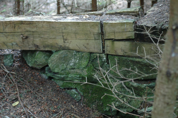
Figure 8. Moss development on the foundation stones of the cabin.
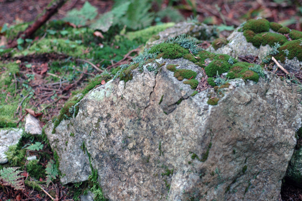
Figure 9. Thick mass of moss on cairn rocks.
A week after our trip, Tom wrote to me saying:
"It is the first site I
have seen that the sole reasonable explanation for the cairns is of
Native American origin. Those cairns obviously have nothing to do with
agriculture. They clearly predate the fire tower and original hiking
shelter based on their moss development. Loggers did not work in that
area, and being a forested summit it is unlikely any hikers would have
gone up there prior to the Long Trail being established in the early
1900s. So the only reasonable explanation is that they are Native
American."
6
Two months after our trip to Glastenbury, I
contacted Norton Miller, Principal Scientist and Curator of the
Bryology and Quaternary Paleobotanical Collections at the New York
State Museum in Albany. Professor Miller has wide experience in botany,
having taught at Harvard University and been curator at Harvard's
Arnold Arboretum, in addition to appointments at the University of
North Carolina and Michigan State University. I sent Professor Miller
digital photographs of the cairns and details of the moss development
on them. He replied that using mosses for dating is fraught with
difficulties, but he thought that the moss mats on one image were
probably around 100 years old (see Figure 2). For example, he wrote
that, 'the northeastern spruce forest often has almost continuous
moss (and liverwort) ground cover, because, among other factors, the
climate is right for bryophytic growth. 7 Much more accurate
dating could be obtained by taking a core from some of the trees near
the cairns, and also analyzing the soil under the cairns for pollen,8 to
see whether the pollen might indicate agricultural activity. But
Wessels had already dismissed this possibility when he determined that
there had been no prior tree cutting in the area of the cairns. Also,
the trees, being small in size at this altitude, had no practical
economic value.
The evidence from the Glastenbury cairns strongly
suggests they were constructed by Native Americans before this region
of Vermont was settled in the late eighteenth century. However, we do
not know why they are found at this high altitude, or what function
they served. High mountains were considered sacred to the Indians. If
we couple this with the data derived from the large cairn with quartz
at the Oley Hills site,9
along with the stylistic similarity of the
three widely scattered platform cairns and how the incorporation of
quartz links them together, we can sense the weight of evidence
shifting away from a broad colonial interpretation for all these sites
and features towards one that views them more openly as a possible
manifestation of Native American ritualism.
We should finally abandon the unsubstantiated view that Native
Americans had no stone building technology in the Northeast before the
European invasion of the seventeenth century. There is ample
documentary and physical evidence to the contrary, as the following
sampling confirms.
The documentary evidence consists in part of a letter that John Pynchon
wrote to John Winthrop, Jr. in 1654 inquiring about the 'report
of a stonewall and a strong fort in it, made all of stone, which is
newly discovered at or neere Pequot. I should be glad to know the truth
of it fro you selfe, here being many strange reports about it. 10
Then we have descriptions of Indian fences (implying stone rather than
wood) in seventeenth century New England deeds. We can add to this
Jeremy Belknap's description of a stone fortification with
Hopewellian features in Sanbornton, New Hampshire in his History of New Hampshire, published
in 1793,11 which was
later confirmed and substantiated by Timothy
Dwight in the early 1800s12
and E.G. Squier in 1850.13
And for
physical evidence, we have the 4700-year-old stone wall discovered
under the dripline of the Flagg Swamp Rockshelter in Westborough,
Massachusetts,14 and
numerous examples of stone fish weirs throughout
the Northeast. The picture that emerges from all this is that obviously
the regional Native Americans constructed with stone, and probably for
a long time before Europeans reached North America. It is important
that we acknowledge this fact, for some of these impressive structures
are now being lost through greed and ignorance. Robert Thorson, author
of the book Stone by Stone and founder of the Stone Wall Initiative, an
organization that attempts to preserve New England stone walls through
education, has on his website a photo of a truck which has 'WE
BUY STONE WALLS' painted in large letters on the tailgate. Not
only are stone walls, but also cairns, are being sold. A researcher in
New York State told me that two impressive cairns, similar to the ones
on Glastenbury Mountain, were torn apart and sold for their stone. We
don't know if they were Colonial or Indian, but from now on we
should try to find out before more of the past is destroyed in the name
of progress.
This article was previously published in the NEARA Journal, volume 43 number 2.
1. Green Mountain National
Forest Final Environmental Impact Statement
to Accompany the Land and Resource Management Plan, Appendix C,
February 2006, p. 28.
2. E-mail from N. Muller to D.
Lacy, September 15, 2006.
3. E-mail from T. Wessels to N.
Muller, January 4, 2007.
4. E-mail from T. Wessels to N.
Muller, January 5, 2007.
5. Harry O. Holstein, Danny S.
Vaughn, and Robert P. Baier. 'The
Morgan Mountain Stone Mound Complex, Site 1Ca32, Calhoun County,
Alabama,' Journal of Alabama
Archaeology, 35/1 (1989), 53.
6. E-mail from T. Wessels to N.
Muller, September 11, 2007.
7. E-mail from N. Miller to N.
Muller, October 12, 2007.
8. Ibid.
9. N. Muller. Accenting the Landscape:
Interpreting the Oley
Hills Site,' Chapter 10, The Archaeology of Semiotics and the
Social Order of Things, British Archaeological Report S1833, 2008,
129-140. Also available online at
Oley Hills Site.
10. Bridenbaugh, Carl, ed.
The Pynchon Papers, Vol. 1. Letters of John
Pynchon, 1654-1700, Boston, 1982. 12. Pynchon was the founder of
Springfield, Massachusetts and he was writing to John Winthrop, Jr.,
who was then at New Haven, Connecticut. The letter is dated November
30, 1654.
11. Belknap, Jeremy. The
History of New Hampshire, Vol. III, 1792, 67:
'At Sanborntown there is the appearance of a fortress consisting
of five distinct walls, one within the other, and at Hinsdale there is
something of the same kind, but they are vastly inferior, both in
design and execution to the military works found in the country of the
Senekas and in the neighborhood of the Ohio.'
12. Dwight, Timothy. Travels
in New England and NewYork, Vol. 3, New
Haven, 1822, 143: 'Sanbornton contains the ruins of an Indian
fortification, which is remarkable for being formed of five
enclosures.' Dwight's trip was made in October 1812.
13. Squier, E.G.,
'Aboriginal Monuments of the State of New
York,' in Smithsonian Contributions to Knowledge, Vol. II,
Washington, DC, 1851, 86-89.
14. Hoffman, Curtiss.
'People of the Fresh Water Lake: A
Prehistory of Westborough, Massachusetts,' American University
Studies, Series XI, Anthropology and Sociology, Volume 47. New York,
1990, 124, 148.